Socio module
| Virtual society | Socio-Module | Virus spread | Literature | Version | |
|---|---|
| Data | Model | Results |
General
In this area only some statistics were performed based on the virtual society model developed in the Virtual Society section.
Below are some basic numbers and statistical information concerning Poland.
Statistical Poland
Population and the number of women and, as well as the number of households are given in Tab.1.
| Population statistics | |||
|---|---|---|---|
| Population |  x x  |
Households |  x x 
|
| Women |  x x 
| ||
| Men |  x x 
| ||
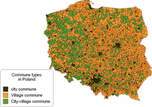
The administrative hierarchy of Poland is the following. The highest level belongs to voivodeship, which, following the European Nomenclature of Territorial Units for Statistics (NUTS) is classified as NUTS-2. There are 16 voivodeships in Poland. Second level constitute about 380 poviats (NUTS-4). The lowest level in the NUTS hierarchy is a commune (NUTS-1). There are about 2500 communes in Poland. There are several types of communes, but basically only three appear in Poland:
- urban/city communes (areas of larger cities)
- village/rural communes (area comprising several villages)
- city-village (urban-rural/mixed) (area comprising one smaller city and several villages)
The distribution of these 3 types of communes in Poland is presented in Fig.1. One can see that the total area of city communes is order of magnitude smaller than the total area of rural communes and about six times smaller than the total area of mixed communes. The corresponding numbers are given in Tab.2.
| Commune type | Population | Area [km2] | Population density [km-2] |
|---|---|---|---|
| urban |  x x  |
15307 | 1328 |
| rural |  x x  |
198457 | 49 |
| urban-rural |  x x  |
99586 | 79 |
Most of the results presented here will be given in communal or poviat resolution. Mostly populated are of course cities. However, some regional population density characteristics are also visible in Poland. Figs.2a,b present the population density in Poland per commune or poviat, respectively. Another, though similar look give Figs.3a,b also in commune or poviat resolution, respectively. They show the area fraction covered described by low population density. By low we mean here population density less than or equal to 0.3 of average population density in given unit (commune or poviat). The average population density was calculated over the commune (or poviat) area, where population density data was given per square km.
From Figs.2 one can see there are very "population" characteristic regions. North-East and Nort-West part of Poland has a very low population density, also these are mostly rural or urban rural communes. The highest population density is visible in the middle of the country, where the capital city is located, and in the southern regions, were highly industrial Slaskie voivodeship is located.


